Thursday, June 7, 2012

The Devil and Wyoming


First off...I apologize for the Badlands and Black Hills post. As I said, my PC crashed before I could finish the post, but I posted it “as is” via my iPad. I had no idea that somehow a bunch of words had run together. I've been working on it this evening to get it readable. I think it's in good shape now, so please reread and check out the additional photos. My further apologies to my Google+ friends who had to put up with all my updates. I don't know how to avoid them.  (The updates, not the friends!)

I got my PC up and running again. I don't know how long it will last, but it's working for now.  Mona has offered use of her Mac Air as a backup.  I’m intimidated by that device, but will definitely take her up on her offer if the PC shoots final craps.
Our objective for this morning was The Devil's Tower Monument in Wyoming. To get there we drove by Sturgis, of legendary motorcycle fame, and then into Wyoming. We continue to be amazed at the changes from state to state...and this change from South Dakota to Wyoming was no exception. It's like they hire a new artist to paint each state, starting at the border! Love it!!!!
First View of Devil's Tower

About 11 miles out we began seeing views of The Devil's Tower. Wow! Wow! Wow! How did that huge tower come to be here!?!? There are three primary theories, but our favorite is that it's the core of a long-gone volcano. 

We hiked around the base of the tower…in awe at every turn.  The verticals on the tower are huge columns, the largest on earth.  Many columns have fallen and are strewn around the base giving the place the feel of an ancient temple. There are areas during our hike that we can hear nothing but the wind whistling through the trees and the sounds of chipmunks and birds around us.  It’s magical!  Little wonder that the Indians still consider this to be a sacred place!


Now it’s time to begin our trip across Wyoming to Yellowstone.  We stopped at the Wyoming Visitor Center to get a recommendation on the best route.  As a result, we’re headed for a pass through the Big Horn Mountains.  We’re told this is most scenic route and fastest even though there is a bit of construction along the way.

Big Horn Mountains in the Distance!
We turn west on Highway 16 and are immediately captivated by the majestic snow-capped mountains in front of us.  They’re huge!  How can there be a pass through that solid wall of giant peaks?!?!  Almost immediately we start going up, up, up!  It takes us no time at all to reach 4500 feet.  Then 6000, then 8000 and finally 9900 feet before we crest the pass.  It’s a beautiful drive up… steep ravines, incredible views and lots of wildlife to see, primarily antelope and mule deer,
with the occasional glimpse of beautiful magpies.
There is a pull-off at the crest.  There is a family there playing in the snow.  Even though it’s 53 degrees there is still lots of deep snow up here!  The plates on their vehicle are from Missouri.  Come to find out, they’re from Sedelia, Missouri and they have recently moved here so the husband can take a job mining Powder River Basin coal.  This coal is a primary fuel for Ameren’s coal plants.  Small world!
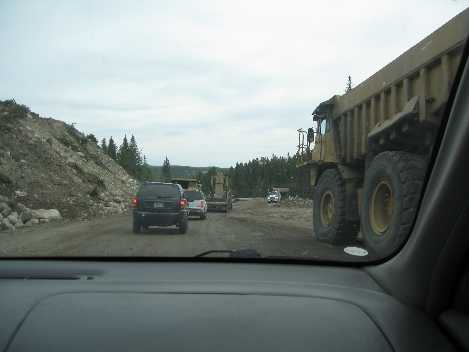
Our convoy ahead of us!
We begin our descent.  Much like the ascent, but on this side there are more rushing mountain streams laden with ice cold water from the snow pack melt.  We keep our windows rolled down so we can enjoy the sound of the rushing water.  Suddenly, we see a sign that says, “Pavement Ends” and we come up to a line of stopped cars.  We’ve hit that construction that the Welcome Center guy told us about.  The next sign says, “Wait for Pilot Car.”  Huh?
Hoping it doesn't fall on us!
A truck with a flashing yellow light turns around and gets in the front of our line of vehicles.  Off we go!  Immediately, we see that the first sign didn’t lie; the pavement ends!   There is no road…just immense machines moving piles of rock, sand and mud to and fro.  The pilot guides us through this maze of machines and mud for several miles.    We’re both laughing almost the entire way.  This so reminds us of Mona’s infamous Taos drive and she’s so happy she’s not driving now!
After miles of slip-sliding we finally get back onto solid pavement.  Now, we’re descending almost as fast as we ascended…with sharp switch back turns and incredible scenery at every turn.  This route is definitely one of our favorites!  We’re still seeing lots of antelope and mule deer and Mona even spots a wild buffalo!
After two hours on the pass, we’re down on the high plains, zooming towards Cody, Wyoming.  The terrain is a little more tame, but beautiful nonetheless.  Finally at Greybul, we turn due west.  Now we can see the Rockies before us, highlighted by the Grand Tetons to the south.  After another hour driving we arrive at Cody!

We quickly check in and walk to our dinner.  Mona has picked out a great spot, Proud Cut Saloon.  The walls are covered with trophy heads (beasts not men, of course) and the steaks are generous and cooked to perfection.  Mmmmm….the relaxation begins.

Tomorrow, it’s Yellowstone!!!!

Wednesday, June 6, 2012

Badlands and Black Hills


We started our day at our normal time, but within ten minutes on the road we gained an extra hour to explore.  Wish we could do that every day!

Badlands
Mona decided to drive all day today.  She’s been to all the places we plan to visit and she wants to maximize my enjoyment of the day.  How sweet is that!?!  About 30 minutes into her drive we start seeing strange rock formations on the south side of the interstate…sharp peaks jutting out of the prairie with an occasional glimpse of a canyon.  Soon, we see spires of banded stone….castles.  This is it…The Badlands.

Virtually, as soon as we enter the park there is a stop and a trailhead. We eagerly set out on our first trail; however, the first sign we see reminds us that even though it’s beautiful you must still be cautious.  No matter! Off we go!   We soon catch up with a ranger who is leading a group and providing geological explanations for the strange beauty we see around us.  This was an inland salt sea, then a swamp, then covered by volcanic ash; all leading to layers upon layers of different colored sediment.  Then about 500,000 years ago erosion began its work, stripping away the softer elements and leaving the harder ones behind to create this incredible fantasy land. 

After our hike, we begin further exploration of the park.  There is a 24 mile loop you can drive through the park and you see wonder after wonder…we must have taken over 100 pictures on this loop.   Every few miles there is a trailhead or a pull-off with information on what you’re seeing.  Each view is a Kodak moment, perfect in its own way!  This is not a fast drive-thru type of place!

One pull-off overlooks a pass where Chief Big Foot and his people passed through The Badlands on their way to Wounded Knee.  You can only imagine the struggles they must have faced as they moved their families and household goods through this impassable maze!   They must have been so relieved to make it through….not knowing the tragedy they would face only a few days later at Wounded Knee.

We finish driving through the park proper and are at the exit. However, in good weather, such as today, you can take a dirt road a few miles farther to the west to see a few other sites.  You know Mona, she can’t pass up a good dirt road so off we go!
Friendly Prairie Dog!
The first thing we see is another cautionary sign.  Buffalo?  Harrumph! We’ve just driven 24 miles of the park and have seen nothing bigger than a bluebird.  We’re not worried about buffalo!  However, we almost immediately see a bighorn sheep in the distance.  Too cool!  We drive about 5 miles further and see a pull-off…..A prairie dog town! Mona virtually jumps out of the car because she loves prairie dogs…as she will repeatedly state over and over as we watch their antics.  They are cute…in a rodent sort of way, and it’s funny to see them suddenly leap into the air and yip!  We wander around the maze of the village for some time and then notice black “humps” just over the hill.  Buffalo! About 100 yards away!!!!

Wild Buffalo!!!!
This is thrilling for me!  My first time seeing wild buffalo!!!  We get in the car and get closer…a couple of hundred feet away.  There are about 40 of them….pretty much ignoring us and doing their buffalo thing: eating, staring off into space and making buffalo pies. I was hoping for the thunder of a racing herd, but this is cool enough!  We take picture after picture and finally tear ourselves away.  We’ve heard numerous warnings about bad weather tomorrow so we want to maximize our day today!

We head out of the park and come to Wall, South Dakota, home of Wall Drug. Of course we have to stop here; it’s a tourist requirement!  What started in the 30s as a struggling little drug store has now blossomed to a huge emporium of tourist delights:gift shops, cowboy and saloon girl statues, cafes, jackalopes, and dinosaurs.  All this because of a free glass of water!  In the 30s the drugstore was struggling…no one came to Wall. The proprietor’s wife thought that if they offered free water to travelers then they might pick up a little more business.  The proprietor went out to put signs up on the highway…and before he returned his business was already starting to boom as travelers came in for a free drink of water. The rest is Wall Drug history! And yes, we had a free glass of water….delicious!

Next stop, Mount Rushmore!  As we turn into the park we immediately see this huge masterpiece.  I’m thrilled and we haven’t even gotten out of the car!  We walk through the Avenue of Flags and get closer…what a masterpiece of art and dynamite!!!  Seeing a picture is nothing like seeing it in person!  What kind of visionary can look at the granite spires of these mountains and see far enough to imagine four presidents carved into stone?!?!  Lucky for us, Gutzon Borglum had that kind of vision and after 14 years this was the result! 

Next up is The Crazy Horse Memorial about 17 miles away.  Whereas,Mount Rushmore was federally funded, this project is privately funded and is still very much a work in progress.  Once again, one man had the vision to turn a mountain into a work of art. What are the odds of two such men working in such close proximity?
Foreground: To-Be Model
Background: As-Is
Korczak Ziolkowski, an apprentice to Gutzon Borglum on the Mount Rushmore project, was approached by a Lakota elder, Henry Standing Bear, to create a memorial to the American Indians.  Ziolkowski was immediately intrigued by the project and chose Thunder Mountain to be the site of the memorial.  He began work in 1947 and worked alone on the project for the first five years.  As time went on, he got more funds to hire helpers and he “grew” a of family of ten children to help with this monumental effort. 

Monumental effort indeed!  When completed the sculpture's final dimensions are to be 641 feet wide and 563 feet high. The head of CrazyHorse will be 87 feet high; by comparison, the heads of the four U.S.Presidents at Mount Rushmore are each “only” 60 feet high.

Ziolkowski died in 1982 and his efforts are being carried forward by his widow and seven of their ten children.  Judging from the current status, it’s going to take at least one more generation of Ziolkowskis to complete this effort!

One of the Needles
Now, it’s time to visit CusterState Park!  We decide to get there via the Needles Highway (thanks to a suggestion by Chris!)  The turnoff to this highway is just a couple of miles from Crazy Horse, so off we go!
Needles Highway is named after the granite “needles” that it threads its way through.  The highway is very narrow with many sharp turns and incredibly small tunnels. Luckily, Mona is still driving so it’s a pretty easy drive for me!  Not so much for her due to 5 MPH turns and 8’4”wide tunnels.  The scenery on this drive is incredible with granite spires reaching to the sky and sheer cliffs dropping off to the pines below.  We are both loving this drive!

After about a half hour we reach the wildlife trail of Custer State Park. We were hoping to see more wildlife, and we were not disappointed.  A doe with her newborn fawn, barely able to walk.  A turkey hen with her chicks chirping behind her.  Antelope grazing beside the road.  And Bill. 
Our first glimpse of Bill
We’ve rounded a curve and there on the road immediately ahead is this HUGE buffalo just standing there!  (We’re certain his name was Bill….he just looked like a Bill, ya know?)  Mona stopped the car about 30 feet away from him. Bill doesn’t move.  We don’t move.  After a few minutes a car approaches from the other way and suddenly stops at the sight of Bill.  Bill doesn’t move.  We don’t move.  The other car doesn’t move.  The universe is in perfect balance and there really is no point in moving to upset that balance.

Finally, Mona decides it’s time…she’s moving first.  We slowly creep forward.  We get close enough to Bill that he can check our odometer!  Okay…we’re past him and now we can breathe again! 
Bill looks at Mona.  Mona looks at Bill.

We continue to drive the wildlife loop seeing more creatures along the way, but no more Bills.  However, we did see another herd of buffalo bedding down for the night.  We get within a hundred feet of them and marvel at their primitive beauty.  (Judging by their behavior they thought we were pretty boring!)

Finally, we make our way back to our hotel in Keystone.  We wander down the boardwalk and climb the stairs to the veranda overlooking Keystone’s main street.  There we relax the evening away, enjoying a quiet dinner, sipping wine and listening to the patter of rain and the occasional gunshots in the Red Garter Saloon below us.  Ah…..a quiet night in the great west!

Monday, June 4, 2012

South Dakota Bound!


Our objective for today was to make it to South Dakota…the closer to The Badlands the better!  We started our day in Iowa City and drove about 240 miles across Iowa. 

Iowa Farm
This part of Iowa is beautiful!  Lots of rolling hills and multi-colored fields dotted with large farm steads.  We kept trying to get a good picture of the “perfect farm” but we were always so enthralled by them that we forgot to grab a camera.  This pic will have to do, but it doesn’t do Iowa justice!
Wind Mill Rest Area
Throughout our travels in the U.S. this year we've seen new windmill farms in virtually every state.  Iowa is no exception and to commemorate this they've built a rest area dedicated to windmills old and new.  This area of the state was settled by the Danish who brought Netherlands-like windmills here over a hundred years ago.  The area is now saturated with modern windmills/wind turbines....interesting to see how the technology has changed, but not changed, in the past 100 years!

We did get this good pic of a gas station that we have only seen in Iowa.  Has anyone seen one of these anywhere else?

Just south of Sioux City we took a slight detour and drove across the Missouri River to visit Nebraska.  We took the first exit and found a cache that I (Marvin) had researched earlier.  This was a “big deal” cache for us as finding it accomplished our goal of finding geocaches 100 consecutive days in a row.  We set this goal after meeting a cacher in Palm Desert, CA who had recently completed a similar goal.  Hard to believe we actually did it!!!  (Hmmm….how much longer can we go????)

Around 1:00 we crossed into South Dakota!!!!  Visiting this state has been a dream of mine since I became infatuated with the Lakota Sioux Indians back in my high school years.  My desire to visit here was only intensified when I linked up with Mona who has told me stories about The Badlands and The Black Hills ever since I’ve known her.  At last….South Dakota!!!!
S.D. Visitors' Center
We stopped at the South Dakota Visitors’ Center and loaded up with brochures and information.  Armed with our new-found knowledge we headed north on I-29, then turned west on the infamous I-90. 

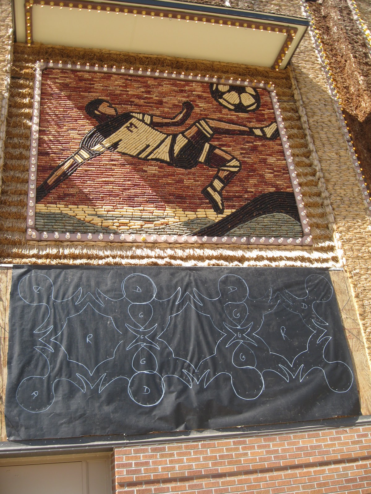
Lower mural is in draft
In virtually no time we were at Mitchell, South Dakota; home of the world’s ONLY corn palace.  Two of the exterior walls of this huge venue are lined with murals made of corn, corn by-products, wheat, barley, and other grain products of the region.  The murals are redesigned and remade every year.  This year’s theme is youth athletics and the remake was in progress.  We got to see one finished wall, pictured on Facebook, and a wall in progress, pictured here.  The artist draws a stencil (cartoon) on the panel and then they fill it in with the appropriate grain products.  Very cool!
Approaching the MissouriRiver in S.D.

Now, back to our westward journey on I-90.  This part of South Dakota is pretty flat with huge fields of different grain crops.  There are also several exits that are barely signed, because they go virtually nowhere.  Nowhere…..just a dirt or gravel road headed off into the distance.
As soon as we crossed the Missouri River we started seeing changes in the geography: more rolling hills and peaks in the distance.  Also, the fields became more dedicated to livestock instead of primarily grain crops.
One of many many!
Throughout our travels in this state we have been constantly greeted by Wall Drug signs.  Seems like there is one or two every mile proclaiming:  “5 cent coffee”,” free ice water”, “dinosaurs in the backyard.”  Wall Drug seems to have it all!  Can’t wait to visit!

Finally, we reach our destination, Murdo, South Dakota.  This is a perfect stopping place for us…only 60 miles from The Badlands and more importantly, just east of the time zone change.  Mona can sleep in tomorrow and in 5 minutes we drive into the Mountain Time Zone and gain back an hour!!!  Gotta love it!

Locals at the Buffalo Bar
As we checked in we asked where to eat.  (There are five restaurants in Murdo so choosing can be difficult.)  There are only two places that serve “meals” and the manager pointed us to The Buffalo Restaurant and Bar….about 500 feet from our motel.  This turned out to be perfect for us.  Mona had the grilled walleye and I had the buffalo steak.  Both were perfect and were served by a Jessica (TrueBlood) look alike.  She was a dead-ringer for Jessica!

Afterwards we stopped at the Buffalo Bar…turn left as you enter instead of right for the restaurant.  Had a beverage and headed back to the motel.  Gotta rest up for The Badlands!!!!

Sunday, June 3, 2012

WWII and Beyond


Today, we started our latest trip: headed to the northwestern and northern states: The Dakotas, Washington, Oregon, Minnesota, etc.

We began our trip by visiting Peoria, Illinois with Monte and Aleta to see a reenactment of one of the battles of Normandy. Before the battle we were briefed by representatives of both sides (Axis and Allies) to learn about their uniforms, weapons and the backgrounds of their regiments. 

The last speaker was a member of the U.S. Signal Corps who represented those who used carrier pigeons for communciations.  Virtually, every nation in WWII used carrier pigeons. The U.S. trained over 52,000 pigeons and used over 36,000 in combat.  And, we also learned that Maidenform designed the best pidgeon "bra" used to carry pidgeons near your chest.
One of the most interesting things we learned that later in the war, the Allies had shot down so many German planes that the Luftwaffe was overstaffed.   However, the infantry was understaffed due to fighting on two fronts.  Goering decided to convert his airmen into infantry…giving them minimal training and poor leadership, then sending them into battle.  This was very interesting to me as Mona/Monte’s dad brought home a war souvenir….a Luffwaffe bayonet.  Until today, we didn’t know why a Luffwaffe officer would need a bayonet!

Axis Camp
After the briefing, we walked through the Axis encampment.  There were lots of different kinds of vehicles and arms…all of which we’ve heard about, but never seen before in person…including a fully operational Panzer.  Even though I knew these were no threat to me, it was still scary to see these tanks that had killed so many of our people.  I was also a little creeped out by the German re-enactors….they were a little too authentic.


At 1:00 it was time for the battle.  We watched men from both sides “melt” into the woods with their camo uniforms.  Suddenly, rifle fire!  Then machine gun fire.  Soon men were falling on either side…..and a German howitzer was quickly put in place just in front of us.  The ground started shaking from the howitzer rounds and we were surrounded by smoke and the smell of gunpowder.

German Panzer v Allied Mechanized Howizter
Then an Allied self-propelled howitzer slowly got into the action.  It looked as though the Allies were easily going to win……until the Panzer got into the fray.  Once he joined in, the battle was virtually over.  The Panzer ruled!  Tackling target after target….and this giant was as quiet as my Intrigue.  Amazing to see this large of a machine go so fast and so quietly!

As I said, the battle was soon over and it was time to leave.  Tried to visit Jonah’s for oysters, but they were closed.  Settled for Joe’s Crab Shack….love their steamed pots!  Afterwards, we parted company with Monte and Aleta and headed west.

We’re now just outside of Iowa City.  Tomorrow, we head for South Dakota!